jueves, 8 de enero de 2015

GEOGRAFÍA FÍSICA DE LA TIERRA

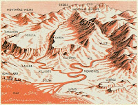
EL RELIEVE

El relieve es el conjunto de formas que presenta la corteza terrestre.

http://contenidos.educarex.es/sama/2010/csociales_geografia_historia/flash/relievecontinental.swf


http://chopo.pntic.mec.es/ajimen18/GEOGRAFIA3/index.html


http://www.juntadeandalucia.es/averroes/carambolo/WEB%20JCLIC2/Agrega/Medio/El%20relieve%20de%20Espana/contenido/cm15_oa02_es/index.html

RELIEVE COSTERO

http://contenidos.educarex.es/sama/2010/csociales_geografia_historia/flash/relievecostero.swf


http://nea.educastur.princast.es/relieve/cc/data/act2.swf

ACTIVIDAD: OBSERVANDO LAS FORMAS DEL RELIEVE

RELIEVE SUBMARINO

http://contenidos.educarex.es/sama/2010/csociales_geografia_historia/primeroeso/tema2/fondo_oceanos.html


WEBQUEST: EL RELIEVE


ACTIVIDAD: CORDILLERAS DEL MUNDO

MONTAÑAS MÁS ALTAS  DE  CADA CONTINENTE
  Asia:   Everest (8 848 m) -Cordillera del Himalaya (Tibet, Nepal)
              K2 (8 611) -  Cordillera del Karakórum (China, Pakistán)

América :Aconcagua  (6 962 m) - Cordillera de los Andes (Argentina) 

 McKinley (6 194 m) - Cordillera de Alaska (Estados Unidos). El más alto de América del Norte.

África: Kibo  (5 895 m) - Kilimanjaro (Tanzania)

Europa:Elbrús (5 642 m) -Cordillera del Cáucaso (Rusia)

Antártida: Vinson (4 897 m) 

Oceanía: Puncak Jaya  (4 884 m) - también conocido como monte Carstensz  es la montaña insular más alta,  está situada en la isla de Nueva Guinea. Se encuentra en las montañas Sudirman (Indonesia).


http://www.juegos-geograficos.es/desiertos.html


EL CLIMA

LAS COORDENADAS GEOGRÁFICAS
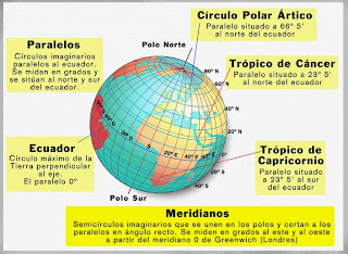
Las coordenadas geográficas son unas líneas imaginarias llamadas paralelos y meridianos que se trazan sobre un globo terráqueo o un mapa y nos permiten localizar un punto exacto sobre la superficie terrestre.
  • Paralelos. Son  circunferencias imaginarias paralelas al Ecuador o paralelo 0º. A partir de éste, se trazan los demás de 0º a 90º hacia el norte y el sur.
  • Meridianos. Son semicircunferencias trazadas del Polo Norte al Polo Sur. El más importante es el Meridiano de Greenwich o Meridiano 0º. Se enumeran de 0º a 180º, tanto hacia el este como hacia el oeste.
http://geografiasenred.weebly.com/coordenadas-geograacuteficas.html

http://www.primaria.librosvivos.net/archivosCMS/3/3/16/usuarios/103294/9/5EP_Cono_cas_ud9_paralelos_merid/frame_prim.swf

LA RED GEOGRÁFICA

http://contenidos.educarex.es/sama/2010/csociales_geografia_historia/flash/coordenadas2.swf

COLECCIÓN DE ACTIVIDADES: COORDENADAS GEOGRÁFICAS.EDUCAPLAY


http://www.juntadeandalucia.es/averroes/carambolo/WEB%20JCLIC2/Agrega/Medio/Tierra/Del%20sistema%20solar%20a%20nuestro%20planeta/contenido/cm08_oa03_es/index.html


LOS HUSOS HORARIOS


http://contenidos.educarex.es/sama/2010/csociales_geografia_historia/flash/husohorario2.swf

LOS CONTINENTES


http://www.e-junior.net/juniornet/geographic/swf/munmp001.swf


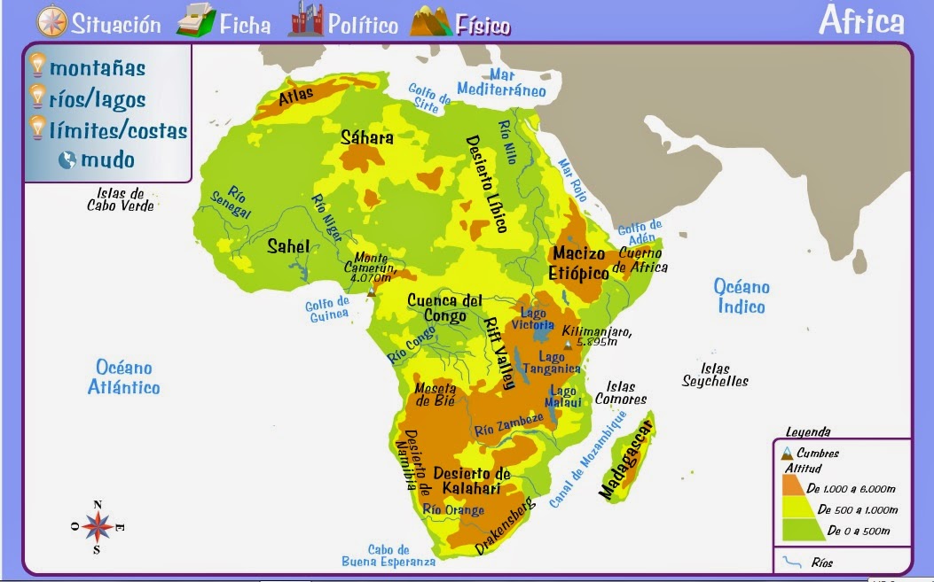
ÁFRICA

http://www.e-junior.net/juniornet/geographic/swf/afrmp001.swf


http://serbal.pntic.mec.es/ealg0027/africaorog1e.html


http://serbal.pntic.mec.es/ealg0027/africaorog2e.html
  

http://serbal.pntic.mec.es/ealg0027/afririos1e.html


http://serbal.pntic.mec.es/ealg0027/africostas1e.html


RELIEVE DE ASIA Y ÁFRICA

ASIA


http://www.e-junior.net/juniornet/geographic/swf/asimp001.swf

ASIA
Es el continente más grande de la Tierra. Está situado en dos hemisferios.

 LÍMITES
 
AL NORTE: OCÉANO GLACIAR ÁRTICO. 
AL SUR: OCÉANO ÍNDICO.
AL ESTE: OCÉANO PACÍFICO. 
AL OESTE: EUROPA, ÁFRICA, MAR MEDITERRÁNEO, MAR NEGRO Y MAR CASPIO.

RELIEVE 


Es muy montañoso, tiene grandes mesetas y llanuras. Sus costas son variadas las hay rectas y recortadas.


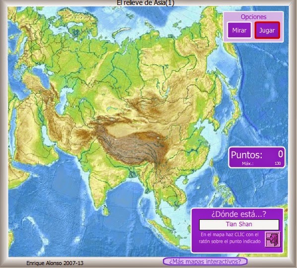
CORDILLERAS Y MACIZOS: HIMALAYA, KARAKÓRUM, TIAN SHAN,  MONTES ALTÁI, MONTES TAURO, MONTES ZAGROS, CÁUCASO Y LOS MONTES URALES.

 MONTE MÁS ALTO: EVEREST. 
 
LLANURAS: LA DE SIBERIA OCCIDENTAL  Y LA GRAN LLANURA CHINA.


MESETAS: SIBERIA CENTRAL, MONGOLIA Y TIBET.


PENÍNSULA: ANATOLIA, ARÁBIGA, DECÁN, INDOCHINA, DE MALACA, COREA Y KAMCHATKA.


DESIERTOS: GOBI,  TAKLAMAKÁN, KARAKUN Y THAR.


RÍOS


VERTIENTE ÁRTICA: OBI, YENISÉI Y LENA. 


VERTIENTE PACÍFICA: AMUR, HUANG-HE (río Amarillo), YANG-TSÉ Y MEKONG.


VERTIENTE ÍNDICA: BRAHMAPUTRA, GANGES, INDO, TIGRIS Y ÉUFRATES.


LAGOS

CASPIO, ARAL Y BAIKAL (el más profundo del mundo).


ISLAS

Asia tiene muchos archipiélagos entre los que destacan los de: JAPÓN, FILIPINAS  E INDONESIA.


CLIMA

Tiene climas CÁLIDOS, TEMPLADOS Y POLARES.

ESQUEMA DEL RELIEVE DE ASIA

MAPAS DE ASIA


ACTIVIDADES INTERACTIVAS
http://serbal.pntic.mec.es/ealg0027/asiaorog1e.html


http://serbal.pntic.mec.es/ealg0027/asiarios1e.html


ASIA FÍSICA Y ACTIVIDADES INTERACTIVAS

AMÉRICA

https://luisamariaarias.files.wordpress.com/2011/07/mapa-fc3adsico-de-amc3a9rica.jpg


AMÉRICA

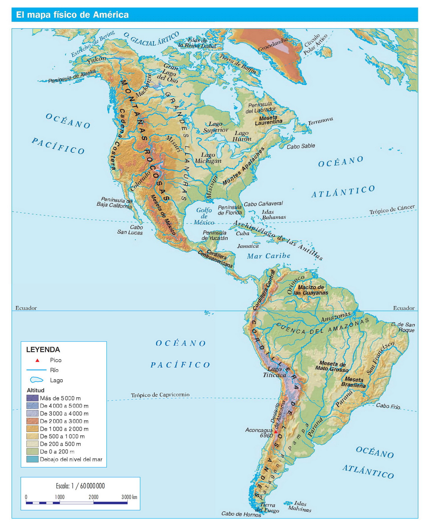
Es el segundo continente más grande de la Tierra. Está situado en los dos hemisferios. Está separado de Asia por el estrecho de Bering.

 LÍMITES 
AL NORTE: OCÉANO GLACIAR ÁRTICO. 
AL ESTE: OCÉANO ATLÁNTICO. 
AL OESTE: OCÉANO PACÍFICO.
AL SUR: EL PASAJE DE DRAKE.

RELIEVE 

En América predominan las grandes cadenas montañosas y las grandes llanuras. Sus costas son muy recortadas.


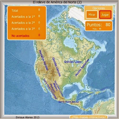
CORDILLERAS Y MACIZOS: MONTAÑAS ROCOSAS, CADENA COSTERA, LOS ANDES, LOS APALACHES, MACIZO D LAS GUAYANAS.
 MONTE MÁS ALTO: ACONCAGUA. 
 
LLANURAS: LAS GRANDES LLANURAS DEL NORTE.


MESETAS: MESETA DE BRASIL Y PATAGONIA.

PENÍNSULA: ALASKA, DEL LABRADOR, BAJA CALIFORNIA, FLORIDA Y YUCATÁN.

DESIERTOS: ATACAMA.


RÍOS

VERTIENTE ÁRTICA: MACKENZIE.

VERTIENTE PACÍFICA: YUKÓN, COLUMBIA Y COLORADO.

VERTIENTE ATLÁNTICA: MISSISSIPI-MISSOURI, GRANDE, ORINOCO, AMAZONAS, SAN FRANCISCO, PARANÁ Y URUGUAY.


LAGOS
GRAN LAGO DEL OSO, SUPERIOR, MICHIGAN, HURÓN, ERIE, ONTARIO Y TITICACA. 


ISLAS

ISLAS DEL ÁRTICO, LAS ANTILLAS (la más grande es Cuba), LAS BAHAMAS, LAS MALVINAS, GROENLANDIA Y TERRANOVA.


CLIMA

Tiene climas CÁLIDOS, TEMPLADOS Y POLARES.

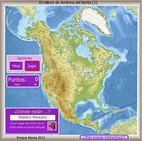
http://www.e-junior.net/juniornet/geographic/swf/amnmp001.swf

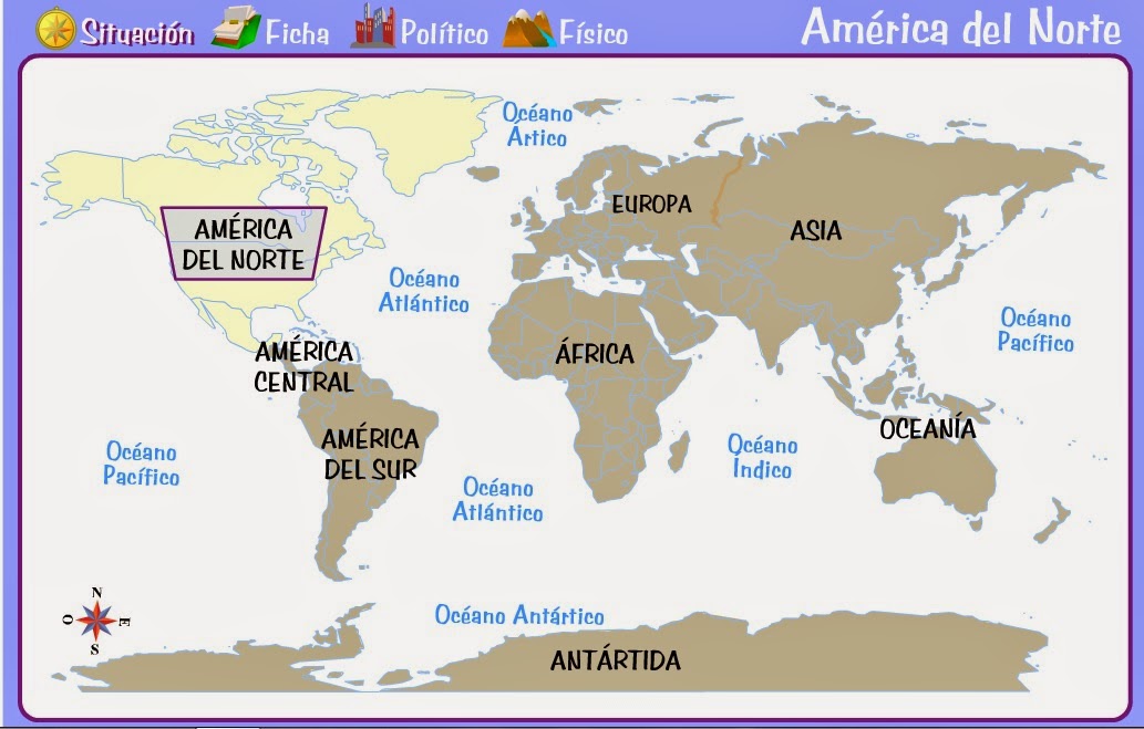
AMÉRICA FÍSICA

ACTIVIDADES INTERACTIVAS
http://serbal.pntic.mec.es/ealg0027/amnororog2e.html


http://serbal.pntic.mec.es/ealg0027/amnororog1e.html


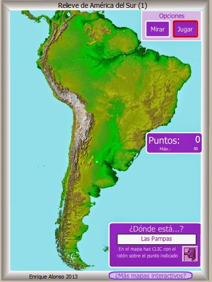
http://serbal.pntic.mec.es/ealg0027/amsurorog1e.html


RÍOS Y LAGOS DE AMÉRICA DEL NORTE


http://serbal.pntic.mec.es/ealg0027/amerisurios1e.html


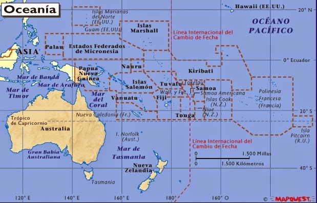
OCEANÍA


http://go.hrw.com/atlas/span_htm/oceania.htm


OCEANÍA

Es el continente más pequeño de la Tierra. Está formado por Australia y por miles de islas del océano Pacífico.


RELIEVE 


AUSTRALIA
Tiene un relieve, en general, llano. Sus costas son recortadas en el norte y rectas en el sur.

CORDILLERAS:LA GRAN CORDILLERA DIVISORIA.
MONTE MÁS ALTO: Monte KOSCIUSZKO.

PENÍNSULA: CABO YORK.

DESIERTOS: GRAN DESIERTO VICTORIA, GRAN DESIERTO ARENOSO, DESIERTO SIMPSON Y DESIERTO GIBSON.


RÍOS
Los ríos de Australia son irregulares y poco caudalosos.


VERTIENTE ÍNDICA: MURRAY-DARLING
VERTIENTE DEL LAGO EYRE: COOPER


LAGOS: EYRE.

RELIEVE DE LAS ISLAS
Las islas son en general muy montañosas.


OCEANÍA FÍSICA

http://www.juegos-geograficos.es/paises_oceania.html

RÍOS DE LA TIERRA

http://www.juegos-geograficos.es/rios.html


viernes, 3 de octubre de 2014

LA REPRODUCCIÓN HUMANA
 
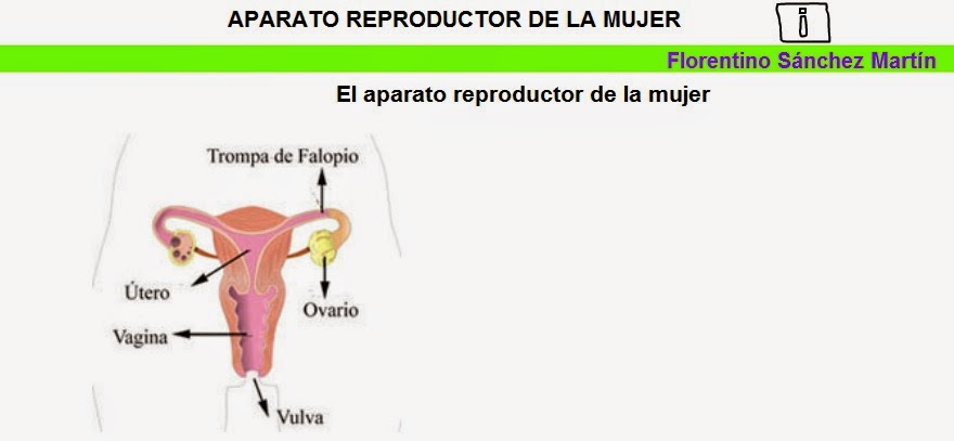
LA  FUNCIÓN  DE  REPRODUCCIÓN

Es una función vital que permite a los seres vivos tener descendientes que impidan que su especie se extinga.

Hay dos tipos de reproducción:
 
 
http://www.juntadeandalucia.es/averroes/ceip_san_rafael/REPRODUCCION/REPRODUCCION.html


http://www.librosvivos.net/smtc/homeTC.asp?TemaClave=1064


http://www.primaria.librosvivos.net/archivosCMS/3/3/16/usuarios/103294/9/6EP_Cono_cas_ud4_203/frame_prim.swf


http://cplosangeles.juntaextremadura.net/web/edilim/tercer_ciclo/cmedio/las_funciones_vitales/la_funcion_de_reproduccion/el_aparato_reproductor_de_la_mujer/el_aparato_reproductor_de_la_mujer.html


http://cplosangeles.juntaextremadura.net/web/edilim/tercer_ciclo/cmedio/las_funciones_vitales/la_funcion_de_reproduccion/el_aparato_reproductor_del_hombre/el_aparato_reproductor_del_hombre.html


LA FECUNDACIÓN

http://blog.educastur.es/ciclo2/files/2007/10/la-fecundacion.swf


http://www.editorialteide.es/elearning/Primaria.asp?IdJuego=943&IdTipoJuego=8


http://www.wikisaber.es/Contenidos/LObjects/human_fert/index.html


FECUNDACIÓN, EMBARAZO Y PARTO

EL  EMBARAZO

http://www.primaria.librosvivos.net/archivosCMS/3/3/16/usuarios/103294/9/cm4_u3_act1_bb/frame_prim.swf

NOSOTROS FUIMOS EMBRIONES


EL EMBARAZO POR DENTRO


EL PARTO


EL CICLO MENSTRUAL

Al alcanzar la pubertad, en el sexo femenino empieza a producirse la maduración de los óvulos,  uno cada mes, y la preparación del útero para un posible embarazo. Si el óvulo no es fecundado, el recubrimiento de la pared del útero se expulsará. Todo este proceso se denomina ciclo menstrual y comprende todos aquellos sucesos que se dan entre una hemorragia, también llamada menstruación o regla, y la siguiente. Este ciclo suele durar 28 días.


EL CICLO MENSTRUAL. PROYECTO BIOSFERA

CARACTERES SEXUALES


http://cplosangeles.juntaextremadura.net/web/edilim/tercer_ciclo/cmedio/las_funciones_vitales/la_funcion_de_reproduccion/los_caracteres_sexuales/los_caracteres_sexuales.html


ACTIVIDADES

ACTIVIDAD INTERACTIVA. PROYECTO BIOSFERA

ACTIVIDAD INTERACTIVA. PROYECTO BIOSFERA
 
ACTIVIDAD INTERACTIVA. C. P. LOS ÁNGELES

AUTOEVALUACIÓN. CEIP GRAN CAPITÁN

miércoles, 17 de septiembre de 2014


ACTIVIDADES DE 6º DE  PRIMARIA


REGLAS DE ACENTUACIÓN

Actividades interactivas para repasar las reglas de acentuación de manera lúdica:

http://www.juntadeandalucia.es/averroes/~23003429/educativa/agudas_llanas.html

http://www.educa.jcyl.es/educacyl/cm/gallery/recursos%20edebe/lengua/10_12_2/1_2_-1_6_405.swf?nada=


http://conteni2.educarex.es/mats/11756/contenido/home.html


lunes, 23 de junio de 2014

ACTIVIDADES  PARA  EL  VERANO


En los siguientes enlaces hay actividades de repaso de 5º de Educación Primaria. Es conveniente que hagáis todos los días algunos ejercicios de Lengua y de Matemáticas y sobre todo debéis leer mucho.

ACTIVIDADES  LENGUAJE. RINCÓN DEL MAESTRO

Tareas verano Lenguaje 5º

Ejercicios de repaso de 5º de E.P. (Lengua y Matemáticas)

ACTIVIDADES DE REFUERZO 5º DE CONOCIMIENTO DEL MEDIO, LENGUA Y MATEMÁTICAS

ACTIVIDADES INTERACTIVAS DE REPASO

http://escueladeverano.net/
CON ACTIVIDADES PARA IMPRIMIR


http://octavio.wikispaces.com/file/view/El+Desafio+de+Primaria

LENGUAJE 5º